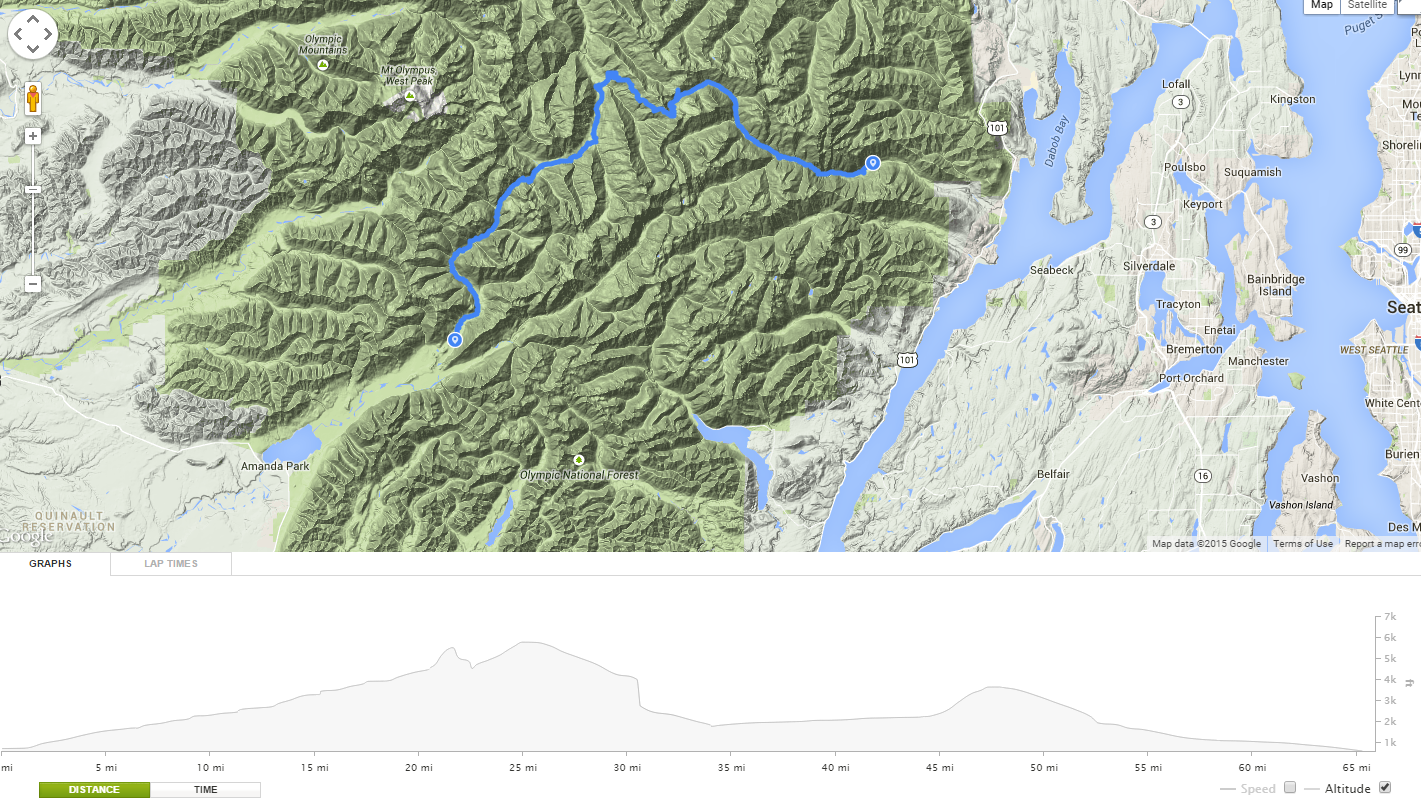
Route: Dosewallips Washout To North Fork Of The Quinault Trailhead
Distance: Around 60 Miles
Days: 6
Longest Day: 17.1 Miles
Campsites: Forest Service Road, Deception Creek, Dose Meadows, Hayes River Ranger Station, Low Divide
Photos: Flickr Set

Days after my dad and I completed the 36 mile hike up to Mount Olympus in 2011 we started looking into where we would take a multi-day hike this year. After much discussion we finally settled on a thru hike of the park from the Dosewallips Road washout to the North Fork of the Quinault trail head with a side trip to Lost Pass.
This roughly 60 mile route would take us on the following trails:
Dosewallips River Trail

Lost Pass Primitive Trail

Hayden Pass Trail

Elwha River Trail

North Fork Of The Quinault Trail

This route would let us experience most of the terrain types of the Olympic National Park as well as experience several river fords (Something we were a bit nervous about, but turned out to not be a big deal). Several years ago there was a major washout 5.5 miles from the Dosewallips trail head. This does add road miles to this route, however the road is mostly grown over with vegetation now and is fairly easy walking.
Day 1: Aug 4th, 2012 – Washout To Forest Service Road
We left on my 31st birthday and because we spent the day with family we got a very late start.

Late Start
We were hoping we could get the 5.5 miles of road hike out-of-the-way before setting up camp. However, since we didn’t get to the washout until after dark, we hiked about a 1/4 mile and camped on an abandoned forest service road.

First Campsite
Even though we didn’t hike very far in the dark I did twist my ankle on a root before we setup camp (Be very careful hiking at night, even with headlights). Luckily, with my boots I could still walk fine but for the next 3 days I did pay for it every time we stopped for the night with a fair amount of pain. Nothing was going to stop us on this hike though. We waited almost a whole year to go!
Day 2: Aug 5th, 2012 – Forest Service Road To Deception Creek
We got a very early start and hiked up the Dosewallips road.

Getting Ready To Go

Entering The Park

Waterfalls

Dosewallips Ranger Station
After we got the 5.5 miles out-of-the-way and ate breakfast at the Dosewallips trail head.

Dosewallips Trail Map
After leaving the trail head we climbed steadily pretty much for the rest of the day. It was also very hot, with temperatures reaching the low 90’s. Luckily there are a lot of creek crossings so water was never a problem.

Backpack On Bridge

Constance Pass Junction Sign

Creek Crossing

Deception Creek Sign

Deception Creek
By the time we reached our next camp at Deception Creek we were very tired. We had hiked roughly 13 miles, most of them climbing in hot temperatures, and after eating dinner we built a fire and relaxed.

Resting By The Fire At Deception Creek
Day 3: Aug 6th, 2012 – Deception Creek to Dose Meadows And Lost Pass
We got another early start. This was our shortest day on the trip. The plan was to go roughly 5 miles and set up camp at Dose Meadows. We were going to use this day as a rest day, knowing that the next couple days would be longer. Dad was doing pretty good, but I was dragging.

Me On The Trail To Dose Meadows
I’m not sure if it was dehydration or what, but this was the hardest 5 miles I’ve ever hiked. Every mile or so I would have to stop and rest, and I felt sick to my stomach. The views were stunning though.

Gray Wolf Pass Sign

Looking Up Towards Gray Wolf Pass

Lost Peak and Lost Pass

Tiger Lily
And while it took us longer than expected, we did reach camp.

Dose Meadows Sign

Olympic Marmot In Dose Meadows
After setting up camp at Dose Meadows we took a side trip up the 1 mile climb to Lost Pass. While it is only 1 mile, you gain roughly 1500 feet of elevation so it is a tough climb.
Dad On The Last Pass Trail

Me On The Last Pass Trail
Without packs though it was a fun climb and I started feeling better the higher we climbed. Reaching the top made the entire day worth it.

Dad And Me On Lost Pass
Simply put: Lost pass is stunning.

Lost Pass
There are views in all directions and all kinds of wildflowers covered the pass. I think I can say that this was my favorite part of the entire trip. Dad and I spent almost 2 hours on the pass just looking around and enjoying the views.

Sentinel Peak, Mount Claywood And Cameron Pass From Lost Pass Panoramic

Wellesley Peak, Thousand Acre Meadows And Sentinel Peak From Lost Pass Panoramic

Me On Lost Pass

Lost Pass Wildflowers
We finally made our way back down from Lost Pass and spent the rest of the day just resting and enjoying the Dose Meadows. The meadows are very peaceful and full of wildflowers. After dinner a buck deer decided it wanted to come visit us and walked right into camp. It was a great ending to the day.

Dose Meadows

Buck In Camp
Day 4: Aug 7th, 2012 – Dose Meadows to Hayes River Ranger Station
Another early start and we were heading up towards Hayden Pass.

Dose Meadows

Ready To Leave Dose Meadows
I was feeling better and we made good time as we climbed the last few miles towards the pass.

Dad On The Trail To Hayden Pass

Hayden Pass
We spent a few minutes at the base of Hayden Pass visiting with some other hikers and resting near the creeks that form the headwaters of the Dosewallips river before starting the last climb up the pass.

One Of The Creeks That Becomes The Dosewallips River Coming Out Of The Rocks

Climbing Hayden Pass
Most of the snow was melted with only a couple of sections of the trail covered and about 45 minutes later we were standing on top of Hayden Pass. Once again the view was stunning. On one side of the pass we could see back down the Dosewallips River valley and on the other side we saw the Elwha River valley as well as Mt. Anderson, Mt. Olympus and the Bailey Range.

Top Of Hayden Pass

View From Hayden Pass

Mt. Olympus
We then took off heading down from Hayden Pass towards our next camp in the Elwha River Valley. A few minutes after Hayden pass we came upon a bear that was sleeping and taking a bath in a small icy pond. He was not thrilled we woke up, glared at us and jumped over the edge into some trees.

The Ice Bear Was Sleeping On – If you Look Close You Can See Bear Entering Trees
The rest of the day was mostly uneventful. The Hayden Pass trail is easy to go down on, it would be a difficult climb, but by 3 in the afternoon we had met up with the Elwha River trail and were soon at our next camp at the Hayes River Ranger Station.

Elwha River Trail Sign

Hayes River Ranger Station
We spent the afternoon exploring around the ranger station and lounging in the nice chair that was on the front porch of the ranger station. Never underestimate how nice a chair can be after 30 miles of hiking. 🙂

Finally Found A Chair In The Wilderness!
Day 4 ended up being an 11 mile day.
Day 5: Aug 8th, 2012 Hayes River Ranger Station to Low Divide

Ready To Head Out For Another Day

Bear Cans?!?! 🙂
The plan for Day 5 was to hike from the Hayes River Ranger Station to Chicago Camp and have another shorter rest day. We set off and were making good time. The Elwha River Trail is a mostly flat trail, which was a nice change from all the climbing we had done to get there.

Dad Crossing The Hayes River
Elwha River Trail
We arrived at Chicago Camp around lunch time.

Sign At Chicago Camp

Taking A Break At Chicago Camp
After a nice lunch by the river, we decided we were not ready to stop for the day and wanted to push up towards the Low Divide. The river ford at Chicago Camp was easy. There were a bunch of trees down so we could simply walk across. If we would have had to go through the water it would have been about knee-deep and was moving at a pretty good pace, so I’m glad there was an easier way across.

Elwha River At Chicago Camp

A Nice Path To Ford The River
We knew that once we left Chicago camp we would have to climb the 3+ miles up to the Low Divide as there are no other places to camp. The climb was pretty steep, but we made it to the Low Divide in a couple of hours.

Up, Up, Up

Lake Mary

Lake Margaret and Mount Seattle
After resting at Lake Mary and Lake Margaret we made our way to the Low Divide and explored a bit before setting up camp. The Low Divide should have been awesome. The views were nice and the weather was mostly nice. However, the mosquitoes ate us alive. We ended up having to stay in the tent most of the evening to avoid them. Even with DEET they still attacked us through our clothes and I had over 50 bites. Nasty little buggers. I was very happy to get going the next morning. 🙂

Low Divide

Low Divide Camp

Clouds Rolling Into The Low Divide

Low Divide Rangers Station
Day 5 ended up being around a 12 mile Day.
Day 6: Aug 9th, 2012 – Low Divide to North Fork Of The Quinault Trailhead
The plan for Day 6 was to go from the Low Divide to Elip creek which would put us about 6 miles from the North Fork of The Quinault trail head. We left the Low Divide without eating breakfast to avoid those nasty mosquitoes and made really good time over the 3.5 miles to the ford at 16 Mile.

Ready To Head Out Again

Gate At The End Of The Low Divide

Waterfall And Wildflower Filled Meadow

Creek Running Through A Canyon
At the river we ate breakfast, mosquito free, and then forded the river. The ford at 16 Mile was the one ford we were most nervous about, but it ended up being a non issue. The water was between knee and lower calf deep and moving at a good pace, but with two poles (or sticks) we were able to make it across just fine.

16 Mile Ford

Made It Across!
After the 16 mile ford we kept a pretty steady pace along the North Fork Of The Quinault trail and made it to Elip Creek in the early afternoon.

Taking A Break On The Trail

Trappers Creek Shelter

Kimta Creek Bridge

Elip Creek Campsite
We ate lunch and decided that since we had already hiked 11 miles, we could probably walk 6 more and be out a day early. We were having a great time, but it would get us home to our family a day early as well, which after 6 days in the wilderness was nice. We lifted our backpacks up on our shoulders one last time and hiked out the last 6 miles.

North Fork Of The Quinault River

We Made It!
Day 6 ended up being around a 17 mile day.
Final Thoughts:
Overall this was an amazing trip and a great route. We met some great people, such as a couple of scout groups working on their 50 mile badges, and saw some stunning wilderness. I’m truly blessed I can spend this time and make lifetime memories with my dad and I can’t wait to go on many more trips like this in the future.

At The Parking Lot
woowwwww,very nice trip…i hade seen all pic.outstanding beuty,unforgetable Nature’s blessing.u did a great job guya.best of luck.